
Traffic Map Update
It might be time to find our own place after 5 wonderful years in Sawtelle. Emma is about to start a new job in Alhambra and we’re looking for somewhere that is good for both of our commutes.
I’ve been (very casually) working on a script to gather traffic data to help us determine where would be a good place to live. It’s now in a v1 state and ready to be used by any and all! Check it out on GitHub– the readme should describe how to use it.
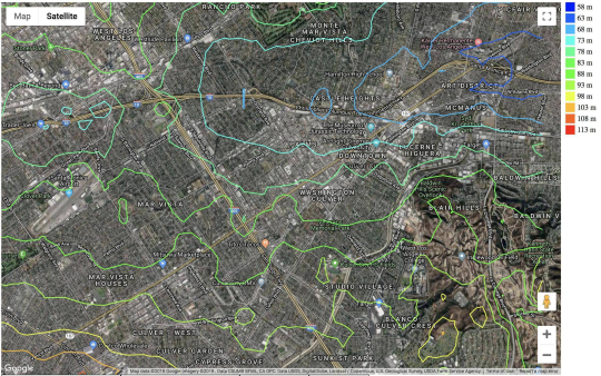
Now for some pretty pictures! The following is a contour map of estimated travel time to Emma’s new job at 7:00 am on a Wednesday aggregated with time coming back at 5:30 pm.
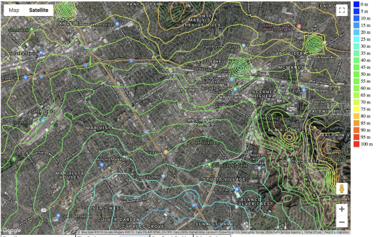
Next is the bike time to/from my job.
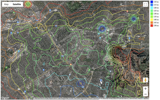
And finally the two combined!
Some commentary:
* There are some artifacts where the data point landed on a freeway. Driving duration is disproportionately low at these points and biking duration doesn’t exist (which I set to -1).
* The minima are pretty close to my job. My theory is that, since biking is slower than driving, the biking data curves down out the driving data.
* East Culver City is the equi-temporal area for our two commutes (but pretty far from a minimum)
* We’ll probably live in the Palms or Ocean Park areas since that would save us ~30-40 mins per day from our current location. Also we really like the locations (commute time isn’t everything!).